
Smart Moves is the federally-supported freight network developed by the Maricopa Association of Governments (MAG) to support your businesses and communities and improve efficiencies for the entire Phoenix Metropolitan Area.
A freight network is a system of identified routes used by large semi-trucks and single-unit parcel vehicles to transport goods. It includes freight corridors, or designated truck routes, that accommodate existing freight clusters, concentrated areas of businesses dependent on these trucks to operate efficiently.
From stocking your local grocery store to depositing online purchases on your doorstep, each of us are touched by freight every day. This network is key to making daily distribution happen as safely and efficiently as possible.
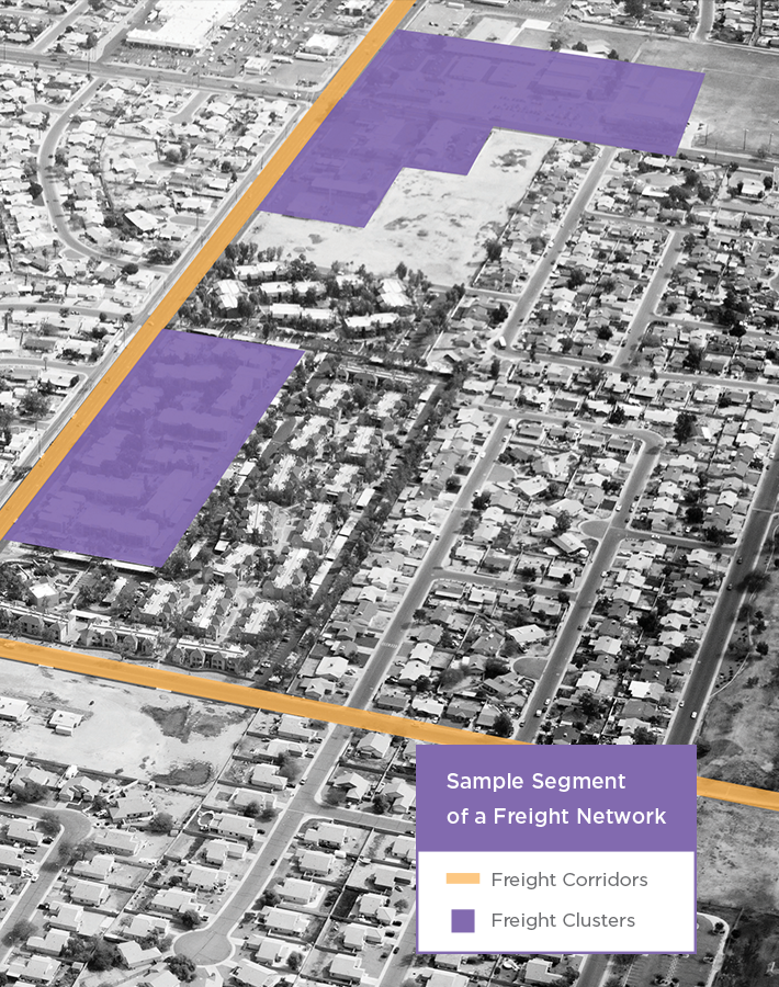
Freight Clusters:
Existing, concentrated areas of businesses dependent on freight to operate efficiently.
Freight Clusters:
Existing, concentrated areas of businesses dependent on freight to operate efficiently.
Freight Corridors:
Designated truck routes.
Freight Corridors:
Designated truck routes.
We all benefit from a freight network modeled with modern needs and technology in mind.

Improves safety conditions for residents, workers, and drivers by identifying appropriate roadways and transportation schedules.

Attracts/retains competitive jobs by moving goods with greater speed and accuracy.

Serves as a master plan for identifying future funding, infrastructure projects and economic development. Our modern infrastructure will serve as a model for other cities for years to come.
Data is an essential ingredient in a thoughtfully-designed freight network. Smart Moves was developed utilizing data-driven observations and timely research including commercial, medical, and transport uses such as:
This comprehensive research is the basis of Smart Moves.
View Map
The Phoenix Metropolitan Area needs to address existing and future freight challenges, and no one knows your area like you. Let us know your thoughts on the identified routes. With your input, we can produce a network that is truly a Smart Move.
Make sure your voice is heard!
Provide feedback on our proposed network routes. Please contact:
Tim Strow
Director of Transportation Policy and Planning
Maricopa Association of Governments
Phone: (602) 254-6300
302 N. 1st Avenue, Suite 300
Phoenix, AZ 85003
[email protected]
View Map
The Phoenix Metropolitan Area covered by Smart Moves is represented by the MAG region. This region encompasses parts of Maricopa and Pinal ounties and all communities therein. The provided map outlines all areas contained within Smart Moves.
Learn more about the MAG region at
http://maps.azmag.gov/
The Maricopa Association of Governments (MAG) is a Council of Governments (COG) that serves as the regional planning and policy agency for the metropolitan Phoenix area. MAG conducts extensive applied research that is fundamental to its core mission of strengthening the reater Phoenix region and State of Arizona. MAG serves a region of more than four million people.
When MAG was formed in 1967, the elected officials recognized the need for data-driven long-range planning and policy development on a regional scale. They realized that many issues, such as transportation, air quality and human services, affected residents beyond the orders of their individual jurisdictions.
MAG was founded in the spirit of cooperation. MAG members believe that by uniting, they can solve common problems, take an active role in long-range regional issues and address concerns that affect all of the communities.
MAG is the regional air quality planning agency and metropolitan planning organization for transportation for all jurisdictions in aricopa County, including the Phoenix urbanized area and the contiguous urbanized area in Pinal County. MAG has also been designated by the Governor to serve as the principal planning agency for the region in a number of other areas, including water quality and solid waste management. In addition, through an Executive Order from the Governor, MAG develops population estimates and projections for the region. Extensive primary research drives this work.
Learn more about MAG at http://www.azmag.gov/
The following maps were created as part of the MAG Freight Transportation Plan that have identified the region's critical urban freight corridor network and the top 60 lane miles submitted to FHWA for approval.
- Draft-MAG Freight Network Map (July 2017)
- Draft Top 60 CUFC Lane Miles (August 31, 2017)
Listed below are draft technical memorandums for the MAG Freight Transportation Plan. The final documents are being revised and an executive summary is being prepared. It is anticipated that all documents will be completed by October 31, 2017.
For more information about the MAG Freight Planning Program, please contact:
Tim Strow
Director of Transportation Policy and Planning
Maricopa Association of Governments
Phone: (602) 254-6300
302 N. 1st Avenue, Suite 300
Phoenix, AZ 85003
[email protected]
The Freight Subarea Project Assessments (SPA) are being conducted by the Maricopa Association of Governments (MAG) and member agencies. The Freight SPAs will recommend projects and policies that will move goods more efficiently and safely through existing industrial clusters of Maricopa County, thereby fostering the development of a diverse and economically thriving place to work and live.
Based on recommendations from the MAG Freight Transportation Plan, the Freight SPAs will identify solutions on or in the vicinity of the federally approved (Top 60 Lane Miles) MAG Critical Urban Freight Corridors. The SPAs will focus on commercial truck freight operations and how freight interacts with other modes of transportation such as passenger cars; freight rail, transit, bicycles and pedestrians.
The study area (Figure 1) for the Southwest Subarea SPA consists of major mile-grid streets and their intersections, along with the Interstate 10 (I-10) interchanges, within the following limits: 107th Avenue on the west, McDowell Road on the north, Buckeye Road on the south, and approximately 0.25 miles west of 59th Avenue on the east. 59th Avenue is not part of the study area due to the Loop 202 South Mountain Freeway currently under construction in the general vicinity of 59th Avenue.
Figure 1 - Study Area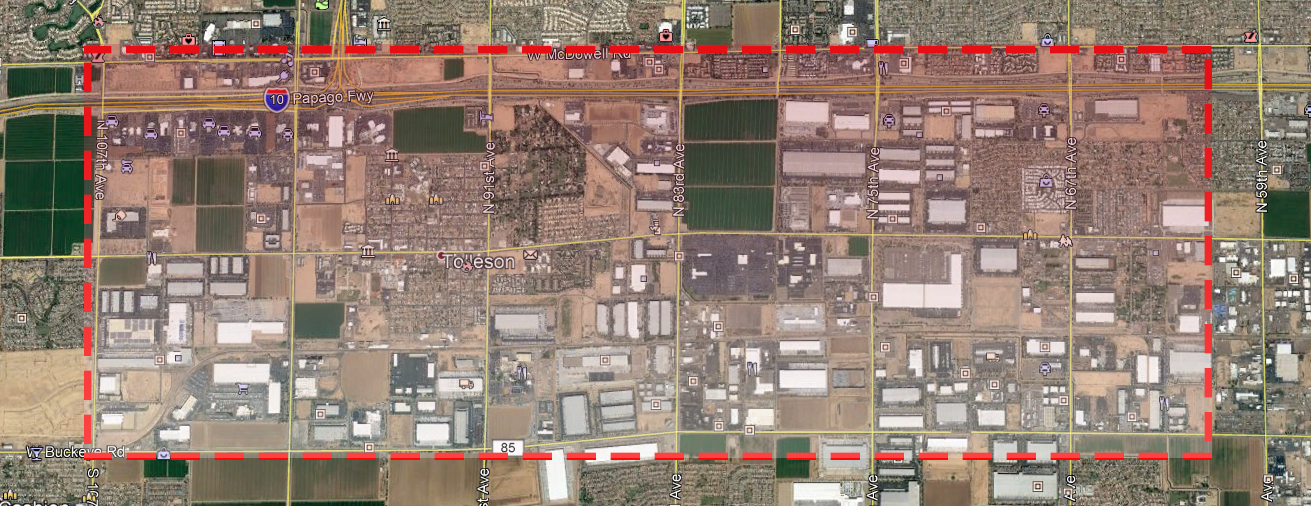
Study area streets are congested with high levels of commercial vehicles and traffic from the shift workers commuting to and from the industrial facilities. The common trend in the Southwest Freight Subarea is for commercial vehicles to leave their specific facility and take the shortest path to I-10. It is not uncommon to see traffic backed up from an I-10 traffic interchange along the connecting arterial streets for several miles during both traditional peak and nonpeak hours. In addition, there are connectivity gaps in the pedestrian and bicycle network that result in potential conflicts between commercial vehicles and pedestrians/bicycles.
Southwest Freight Subarea Project Assessment - Draft Working Paper, Existing Conditions Assessment
Southwest Freight Subarea Project Assessment Fact Sheet
Southwest Freight Subarea Project Assessment Neighborhood Meeting
The Phoenix Metropolitan Area needs to address existing and future freight challenges, and no one knows your area like you. Let us know your thoughts on the Southwest Freight Subarea Project Asessment. With your input, we can produce a network that is truly a Smart Move.
Make sure your voice is heard! Please send all comments to:
Tim Strow
Director of Transportation Policy and Planning
Maricopa Association of Governments
Phone: (602) 254-6300
[email protected]